
Description
Overview
The Circus
Prepare yourself as you begin your historical journey from your hotel or the cruise port. Our tour begins upon arrival into Basseterre the city with an informative drive around the city for approximately 45 minutes. Basseterre: As the capital city of St. Kitts, Basseterre is home to several historical landmarks. Independence Square, formerly known as Pall Mall Square, is the heart of the city the Berkeley Memorial Tower Clock, and the St. George’s Anglican Church.
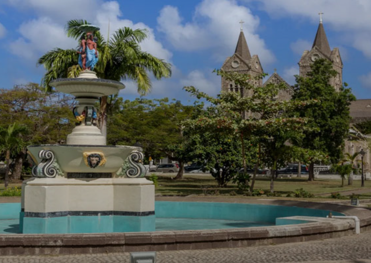
The Circus, a roundabout modelled after London’s Piccadilly Circus was created after a fire destroyed the east of West Independence Square on July 4th, 1867. When Basseterre was rebuilt it was decided to widen the streets and design this roundabout for the ease of movement of fire trucks to avoid a reoccurrence. A clock monument featuring clocks and water fountains was erected and dedicated to a well-known legislator Thomas Berkeley in 1883. The tour guide will pause for 10 minutes at the Circus Clock.
Independence Square
Independence Square; formerly Pall Mall Square, was renamed on the 19th of September 1983 to commemorate the birth of the new nation of St. Christopher and Nevis. Its layout was designed to look like a Union Jack and the streets and houses surrounding it once dated to the mid-eighteenth century. Time and the environment have damaged or destroyed many of them.
St Theresa Catholic Church CO-CATHEDRAL OF THE IMMACULATE CONCEPTION is an ornate church constructed out of grey stone. In the early years of the French occupation of St. Kitts, the Jesuits built a Roman Catholic Church and dedicated it to Our Lady, Notre Dame. It was burned in 1706 during the Anglo-French war and rebuilt later as St. Georges Anglican Church. In 1713 the English forbade public worship of the Catholic religion in St. Kitts. Wealthy Catholic families erected cupolas on the tops of their houses as a sign for other Catholics to come and worship. Only two such buildings remain in Basseterre both on Liverpool Row.
St. George’s Anglican Church
ST. GEORGE’S ANGLICAN CHURCH is the largest church in Basseterre. It stands at the head of Church Street and resembles an English parish church in style. The outer walls are of heavy andesite rock and the roof is covered in slate.
In 1635, at the request of the directors of the Company of the Isles of America, the Provincial of the Capuchin Friars of Normandy assigned three men, Fathers Jerome, Marc and Pacifique de Provins to care for the spiritual needs of the French colonists and to attempt the conversion of the small Kalinago population that remained on the island after the massacre of 1627. In Basseterre they erected a place of worship which Rochefort describes as a fair Church able to contain a very great Congregation.
The Friars also had churches in Cayon and Capis Terre but in 1646, Governor De Poincy felt that they were taking sides against him and ordered them to leave the colony. He replaced them with the Jesuits. In 1672 they built a church which they called Notre Dame.
Bloody Point
Bloody Point is situated to the west of Challengers Village. It gets its name from the Massacre of the Kalinago that took place in the vicinity. One of their own, Barbs gave the English settlers information when the Kalinagoes will not be on alert and the settlers attack the tribe. It is said the river ran so red that it was eventually called Bloody River.
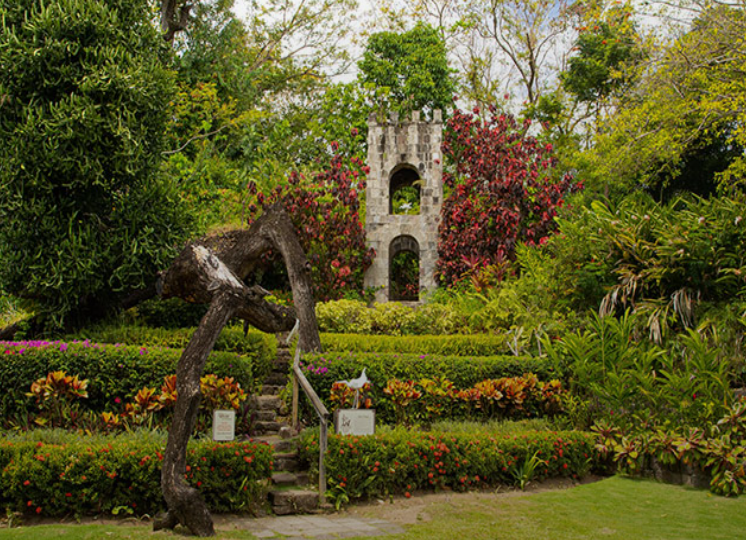
Romney Manor & Caribelle Batik
Romney Manor, nestled within eight acres of lush gardens, is steeped in history dating back to pre-colonial times. Before European settlement began in 1623, the area was home to a Carib village led by Chief Tegreman. Evidence of this indigenous presence remains in the form of Amerindian petroglyphs carved into stones on the nearby Wingfield Estate.
For over 350 years, the estate was a major site for sugar cane cultivation, evolving from animal-powered to water- and steam-powered production methods. Sugar operations ceased in the 2000s, and since the 1970s, Romney Manor has been the home of Caribelle Batik — a celebrated textile workshop known for its vibrant batik art.
Visitors are especially drawn to the magnificent Saman tree on the grounds — a massive, 400-year-old tree measuring 24 feet in circumference and spanning half an acre. Revered as the spiritual heart of the estate, the tree symbolizes the deep connection between nature, culture, and history on this land.
Wingfield Estate
Located in Old Road Town near the Wingfield River, this historic estate lies in the verdant foothills of St. Kitts’ central mountain range. The property is part of the Wingfield watershed — a crucial natural system that supplies over 75% of the island’s freshwater.
Wingfield is also home to some of the most accessible and significant Amerindian petroglyphs in the Lesser Antilles. These rock carvings offer a rare glimpse into the island’s pre-colonial history.
Awarded as the first English land grant in the Caribbean in 1625, Wingfield initially grew tobacco and indigo before transitioning to sugar cane — a crop cultivated here continuously for 350 years. The estate’s cane-crushing operations progressed from animal-driven to water- and finally steam-powered systems, with its water-powered infrastructure being one of the few of its kind in the Eastern Caribbean. Today, Wingfield Estate is both a flourishing archaeological site and a beautifully landscaped heritage destination.
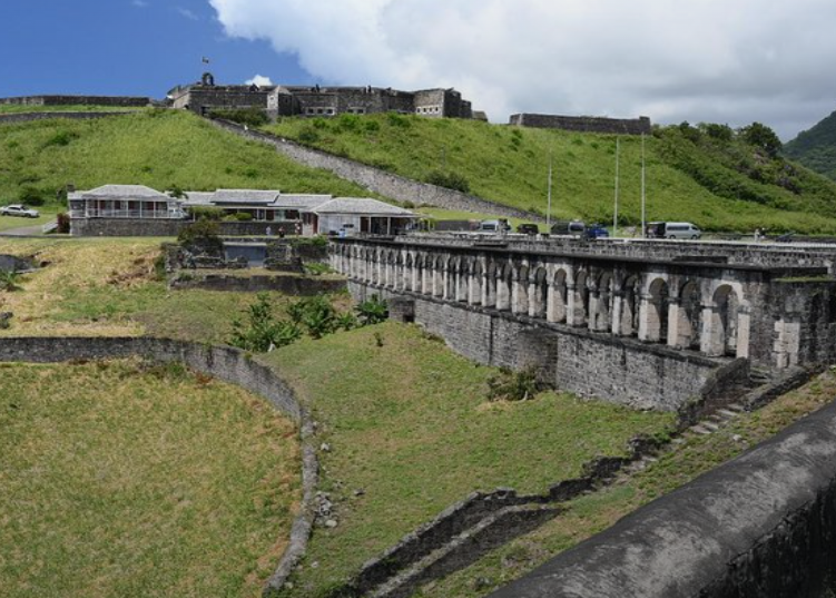
Brimstone Hill Fortress
Constructed between the 1690s and 1790s, Brimstone Hill Fortress stands as a remarkable testament to 18th-century military architecture and engineering. Often described as a “time capsule,” this well-preserved site represents one of the most complete examples of a historic military community in the Caribbean — and holds international significance.
At the heart of the fortress is the Citadel, one of the earliest and finest surviving examples of the “polygonal system” of fortification. Brimstone Hill rises nearly 800 feet, its steep volcanic slopes skillfully shaped by human hands, often at great personal risk. The fortress walls, built from locally quarried volcanic stone and bonded with lime-based mortar made on-site, appear as a natural extension of the hill itself.
From the summit, visitors are rewarded with panoramic views of forested mountains, sugarcane fields, the historic town of Sandy Point, and several nearby islands — once Dutch, English, and French colonies — scattered across the Caribbean Sea.
Black Rocks
Black Rocks, also known as Black Stone, is a dramatic volcanic rock formation on the northeastern coast of St. Kitts, near the town of Saddlers. These jagged formations are remnants of ancient lava flows from Mount Liamuiga, the island’s dominant volcano, which continues to shape the rugged northern landscape. The area is a striking example of the island’s volcanic origins and a popular stop for those interested in geology and natural scenery.
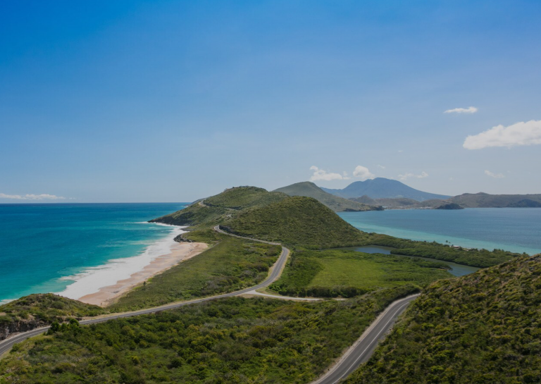
Timothy Hill
Just a short drive from Frigate Bay, Timothy Hill offers one of the most iconic views in St. Kitts. From this elevated vantage point, visitors can gaze upon the dramatic meeting point of the Atlantic Ocean and the Caribbean Sea. The lush green slopes of the southeast peninsula stretch below, and the island of Nevis appears on the horizon. It’s a favorite stop for photo ops and scenic reflection.
Pass By:
Independence Square
St Theresa Catholic Church
Anglican Church
Bloody Point
Includes:
Meet & Greet at cruise port or hotel pickup
Entrance fees
Taxes
Beverage
Scenic drive back to cruise port or hotel
What to bring/wear:
Water
Tour coupon
Camera
Comfortable walking shoes, sunscreen, casual attire, e.g. sun dress, shorts, t-shirt etc.
Tour duration: 4.5 – 5 hours. Time: 9:30am – 2:30pm